The maritime industry is crucial to the world economy, yet seamless connectivity is hard to come by and digitalization of ocean-related services is lagging. While fifth-generation (5G) cellular networks have played a critical role in advancing opportunities across industries and societies, remote areas are falling starkly behind. To expand the capabilities of maritime coverage, a team investigated the integration of unmanned aerial vehicles (UAVs) with existing maritime communication networks (MCNs) to create an on-demand coverage framework.
“Maritime activities, such as marine tourism, offshore aquaculture, and oceanic mineral exploration have seen rapid development in recent years,” said Wei Feng, an associate professor with the Department of Electronic Engineering at Tsinghua University in China. “With the increasing number of vessels, offshore platforms [and] buoys, there has been a growing demand for effective maritime communications.”
Today, satellite-based networks are responsible for a vast majority of communication for vessels at sea, but latency is high and the data rate is much lower than that of terrestrial 5G. With heavily scarce land mass within oceanic zones, building 5G base stations is challenging, and the ones that are deployed on the shore along the coast – Terrestrial based stations (TBS) – often come with restricted coverage areas. Additionally, communication networks require power support and full-fledged backhaul solutions like optical fibres and, given the scale of the ocean, laying power cables or optical fibres across the ocean floor is unmanageable. On the other hand, the surface of the sea often experiences severe waves and winds that greatly affect the quality of communication. Altogether, it is evident that deploying effective communication infrastructure on the ocean is a critical challenge.
Combining UAVs, which are flexible and agile, with the unique capabilities of vessels, the team introduced a hybrid satellite-UAV-terrestrial maritime network by successfully integrating UAV communications into existing MCNs. As illustrated in Figure 1, since UAVs can fly much closer to the end-user, they can significantly increase the transmission rate and reduce communication latency.
The way this hybrid satellite-UAV-terrestrial maritime network works is that UAVs are deployed to bridge the gap between broadband coverage areas and remote spots across the ocean that are not covered by shore-based TBS or marine satellites.
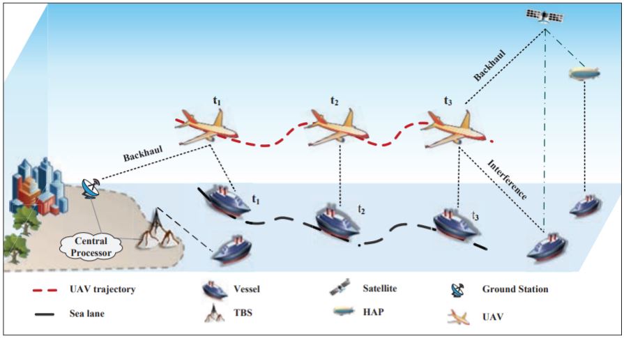
Figure 1: Illustration of the hybrid satellite-UAV-terrestrial network for agile broadband maritime coverage
Rather than moving around freely, vessels often follow sea-lanes or shipping lanes. Think the Suez Canal or The Dover Strait, which are essentially navigation routes used by vessels on wide waterway excursions. Not only do sea-lanes reduce travel time and risk, but they are economic as well. Figure 2 outlines the movement patterns of over 600 vessels in 1 hour. While a few ships deviate from traditional sea routes, the majority keep to shipping lanes, which presents a unique opportunity to leverage UAVs and create an on-demand coverage framework.
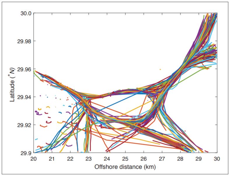
Figure 2: Illustration of the sea-lanes within a coastal area of China, including data from 610 vessels during one hour
When a vessel is traveling outside existing coverage areas, a UAV can be deployed to offer broadband services. It can operate in either a serve-and-leave manner or it can move with the vessel for long-term coverage and broadband services. Once the ship reaches its destination, the UAV can be dispatched to another vessel or sent back to the base station to charge.
According to Wei, enhancing and expanding maritime communications not only benefits consumers who travel for work, but the integration of 5G with maritime verticals also improves the efficiency and safety of industrial activities on the ocean – while drastically reducing costs.
“The hybrid satellite-UAV-terrestrial network is complex due to its irregular and dynamic topology, as well as the harsh maritime environment,” said Wei. “To overcome [these] complexities, we need to use external auxiliary information, such as the shipping lane information of vessels to create [a] radio map, as well as to optimize the network in a process-oriented manner.”
As a next step, Wei and his team are examining the measurement, modeling and spatial-temporal distribution of maritime communication channels and users to further optimize on-demand coverage. They have already built a trial network in a coastal area of China, which could be key in closing the digital divide promised in future six-generation (6G) rollouts.
For more information on 5G, Unmanned Aerial Vehicles and maritime communication, visit the IEEE Xplore Digital Library.