Unmanned aerial systems (UASs) are systems for drones that offer a wide breadth of practical uses in areas like law enforcement. But as facial recognition and similar technologies in drones advance, protecting individual privacy along flight paths has become a rising concern. To help protect non-consenting individuals from privacy infringement, a team of researchers from Vienna University of Economics and Business developed a web-based software solution to manage drone privacy regulation, as well as a framework for how to implement it.
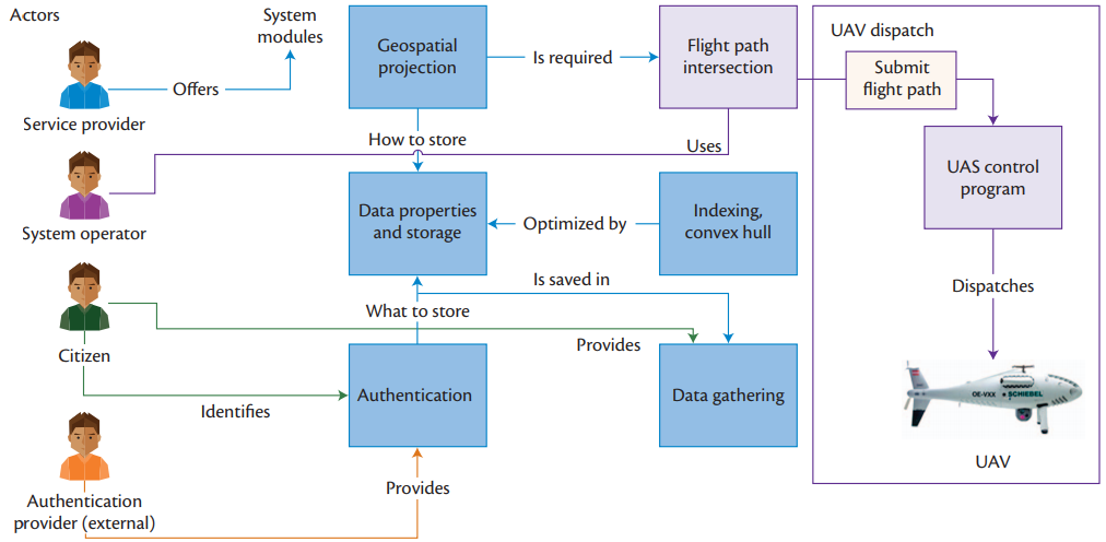
Figure 1: Software System Implementation Framework
Using law enforcement as an example, the proposed framework from the Vienna University team distinguishes between four types of actors, as depicted in Figure 1:
- System operator: A police officer in a UAS control center.
- System provider: The officer’s law enforcement organization.
- Citizen: Any citizen holding legal property in the UAS flight path with privacy preferences.
- Authentication provider: A trusted e-identity service provider.
Prior to a UAS’s launch, the system and actors engaged with the system go through these steps:
- First, the system provider generates coordinates with specific property geospatial projections for the UAS’s flight path. Then the system queries citizen property data and preferences.
- Once the system has privacy preferences and coordinates, an authentication provider checks citizen property flight permissions. The system then records citizen privacy preferences noted by the authentication provider.
- Once privacy preferences are recorded, a flight path is processed by the system operator using the most efficient number of points, as pictured in Figure 2. The final flight path is then calculated and set by the system operator.
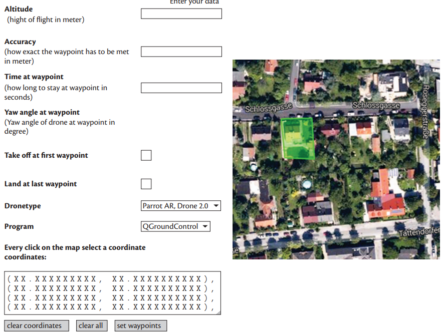
Figure 2: Operator Interface of UAS Dispatch
To verify the effectiveness of the proposed framework and software, the research team developed a web-based prototype that used software known as QGroundControl (QGC) to interact with a Parrot AR.Drone 2.0. An experiment was conducted with 13 people, wherein the participants were asked to create at least one restricted area and select several flight paths. Plus, one or more flight paths had to intersect with a restricted area.
Based on real-time verbal feedback, the team refined the software layout and added a more precise instructional manual. While the mapping features were intuitively useable, they made changes to simplify the menu structure. They also added introductory tutorials on how to use the software.
Following these software updates, a second usability experiment was conducted with eight participants. To better resemble a real-world application, basic authentication functionality and dummy accounts, tailored to the participants’ names, were added. Most participants intuitively built restricted areas for their own or a relative’s home, which demonstrated that the updates increased usability.
Finally, after incorporating all feedback, a third experiment was conducted to evaluate the software’s real-world viability. For this experiment, six participants were asked to select several flight paths that either went around or through two preset restricted areas. If an intersection with a restricted area was found, the coordinate export was disabled, making a launch of the drone impossible. The participants managed to successfully deploy the drone, while selecting a flight path without restricted areas, with no instructions or help.
Although the proposed software and implementation framework are just one piece of a larger conversation that needs to take place, the Vienna University team’s results proved that a fully functional privacy system is indeed possible.
“The proposed framework is a first step towards greater UAS privacy,” said Peter Blank, a process and data analytics professional at PwC Switzerland. “Legislation in a variety of countries has shown that citizens can expect a reasonable degree of privacy on their private properties. By incorporating this framework into legislation, citizens are empowered to consent on whether or not UASs can fly over their properties. To date, this consent can neither be granted nor denied.”
Moving forward, the team hopes its system will have a positive impact on the acceptance of UAS use in public space and will yield to legislation for stricter privacy regulations. If people become more confident their privacy won’t be affected by drone use, drones could become standard in law enforcement and society in general.
For more information on drone privacy, visit the IEEE Xplore Digital Library.